
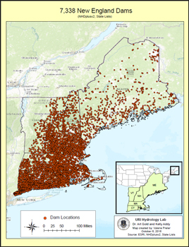
The New England Dams Database is a collaborative effort of the Maine, New Hampshire, and Rhode Island EPSCoR research networks and is compiled from various geospatial, land use, and hydrographic datasets. The current version of the database (version 08/10/18) includes 7186 existing dams throughout New England (2091 in Connecticut; 1783 in Massachusetts; 645 in Maine; 1969 in New Hampshire; 433 in Rhode Island; and 265 in Vermont). The database also includes 258 removed dams in New England (35 in Connecticut; 45 in Massachusetts; 36 in Maine; 63 in New Hampshire; 6 in Rhode Island; 73 in Vermont).
|
Attributes in this database include:
|
 |
Some attributes are applicable to all six New England states, while other variables are specific to just certain states. See the full metadata record for details.
PLEASE NOTE: The New England Dams Database is updated periodically as new information about attributes in the database becomes available or new attributes are added. Users are encouraged to note which version of the database they have downloaded and to join our email list to receive notifications when the database is updated.